
- Warning Type: Yellow warning – freezing rain
- Timing: Early evening through midnight tonight
- Ice Accumulation: Up to 2 millimetres
- Areas: GTA, Hamilton, Waterloo Region, Guelph
- Lake Ontario shore: Rain only, temperatures just above zero
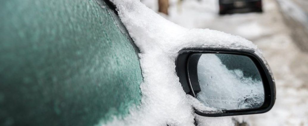
Tonight’s going to be a real pain if you’re driving. Environment Canada just dropped a freezing rain warning on most of southern Ontario – we’re talking Toronto, Hamilton, the whole works. You’re looking at up to 2 millimetres of ice buildup that’ll make roads and sidewalks downright treacherous.
Starting early this evening, the freezing rain kicks in and should wrap up around midnight. Here’s the thing though: patchy drizzle or freezing drizzle might hang around into Friday morning.
Your morning commute could be interesting.
When This Mess Arrives
There’s a low pressure system shoving another batch of rain our way late this afternoon. Both the GFS and Euro models agree – this system’s tracking through and bringing rain that’ll flip to freezing rain early tonight across most spots.
Temperatures are going to hover right at the freezing mark. Surface readings drop to -1°C to -3°C inland by 7:00 PM tonight, which is just fantastic timing for evening rush hour when millions of people will be crawling home on the highways.
Lucky you if you’re right along Lake Ontario’s shoreline. Temperatures stay just above zero there, hitting 1°C to 3°C, so you’ll mostly see rain. Everyone else? You get the ice special.
The worst hits between early evening and midnight. Roads and walkways turn into skating rinks, and honestly, those icy patches are tough to spot until you’re already sliding across them.
Peak freezing rain intensity happens around 8:00 PM to 10:00 PM, piling up ice at 0.5 to 1 millimetre per hour.
That’s pretty aggressive accumulation rates.
Who Gets Hammered
This warning blankets a massive chunk of southern Ontario – about 6.8 million people across the Golden Horseshoe region are in for it. Brantford and County of Brant, Toronto with its 2.9 million residents, Pickering through Oshawa in Durham Region, the Vaughan-Richmond Hill-Markham corridor, Hamilton’s 580,000 people, Guelph and southern Wellington County, Kitchener-Cambridge-Waterloo housing 575,000 residents, Caledon, Mississauga-Brampton with 1.4 million people, Halton Hills-Milton, and Burlington-Oakville.
Millions of people who need to rethink their evening plans and tomorrow morning’s routine.
The lake effect’s actually working in favour of spots right along Lake Ontario’s shore. Those areas see mainly rain because the lake’s still holding warmth at 4°C to 5°C, keeping air temperatures just above freezing. Move inland 5 to 10 kilometres though? You’re in the freezing rain zone where surface temperatures drop below zero.
Quite the difference over such a short distance.
“We’re particularly concerned about the evening commute tonight,” said Dr. Sarah Chen, Warning Preparedness Meteorologist with Environment and Climate Change Canada. “The timing of this event means people will be caught off guard as conditions deteriorate rapidly between 6:00 PM and 8:00 PM when many are still on the roads.”
How This Hits Your Wallet and Commute
Work from home tomorrow morning if you can swing it. Even after the main show wraps around midnight, we might see patchy freezing drizzle into Friday morning – the kind of stuff that catches people off guard during morning rush.
Pretty telling.
The 401 corridor’s going to be absolutely brutal tonight. Windsor through to the GTA, drivers should expect icy conditions and way longer travel times. QEW, Highway 403, and the 404 will all see the same mess.
Ontario Provincial Police typically watch collision rates jump 300% to 400% during freezing rain compared to normal conditions.
That’s a lot of fender benders.
Pearson International Airport already warned airlines about potential delays and cancellations. With over 1,200 flights scheduled tonight and tomorrow morning serving 140,000 passengers, the ripple effects could be huge. De-icing operations cost airlines $2,000 to $5,000 per aircraft depending on size and ice buildup. Weather has the complete breakdown.
Get that ice scraper ready. Even a couple millimetres of ice buildup makes your windshield impossible to see through, and it takes 10 to 15 minutes to clear off properly even with the engine running.
School bus operators across the region are watching this closely. Major school boards including Toronto District School Board, serving 247,000 students, and Peel District School Board with 153,000 students, could announce cancellations affecting over 800,000 students region-wide.
With potential lingering freezing drizzle Friday morning, decisions will likely come by 6:00 AM.
GO Transit activated winter weather protocols, positioning extra crews at key stations and maintenance facilities. The network carries 300,000 passengers daily across 2,000 square kilometres – any service disruptions hit regional mobility hard.
Power Lines and Emergency Crews
Two millimetres of ice isn’t catastrophic, but it’s enough to weigh down tree branches and power lines. Hydro One, serving 1.4 million customers across Ontario, has crews on standby, especially in areas with vulnerable overhead lines. Toronto Hydro positioned extra crews at their 12 district stations to respond quickly to outages affecting their 780,000 customers.
Here’s the math: each millimetre of ice accumulation adds roughly 500 grams of weight per metre of power line.
With 2 millimetres expected, that’s an extra kilogram per metre on lines and branches. Past data shows freezing rain events with 2-5 millimetres typically cause power outages affecting 2% to 8% of customers in warning areas.
Could be worse numbers, but still significant.
“Our crews have been pre-positioned in strategic locations across the service territory,” said Michael Rodriguez, Emergency Response Coordinator for Hydro One. “We’re monitoring weather conditions in real-time and have mutual aid agreements with neighbouring utilities activated. Our goal is to restore any outages within 4 to 8 hours, weather permitting.”
Good news is this isn’t looking like January 1998’s ice storm, which caused $5.4 billion in damage and left 1.6 million people without power for up to six weeks. That event saw ice accumulation of 25 to 100 millimetres across eastern Ontario and Quebec. This is also much smaller than December 2013’s ice storm that hammered the GTA, causing $200 million in damages and leaving 300,000 customers without power for up to nine days.
Still, don’t park under large trees tonight. Even small branches loaded with ice can come down and wreck vehicles or property. Insurance claims from ice-related tree damage typically run $3,000 to $15,000 per incident depending on damage extent.
Slips, Falls, and Hospital Visits
Icy surfaces from freezing rain are different from regular snow and ice – they’re often clear or nearly invisible, making them particularly nasty for pedestrians. Emergency departments across the region typically see slip-and-fall injuries spike 250% to 400% during freezing rain events. Most common injuries? Wrist fractures, hip injuries among seniors, and head trauma from falls.
Not the kind of night for a casual stroll.
Paramedic services are on high alert. Toronto Paramedic Services, responding to 200,000 calls annually, added extra crews for tonight and tomorrow morning. Peel Regional Paramedic Services activated their Severe Weather Response Plan, pre-positioning ambulances strategically to keep response times under their 8-minute target for life-threatening emergencies.
If you absolutely must drive tonight, slow way down and increase following distance dramatically – at least 8 to 10 seconds behind other vehicles. Bridges and overpasses ice up first and stay icy longer. Usual trouble spots like Highway 6 through the escarpment and elevated sections of 400-series highways will be especially treacherous.
Your car’s temperature reading can fool you during freezing rain. It might show 1 or 2 degrees above zero, but road surface can still be below freezing, especially on bridges and shaded areas where temperatures run 3 to 5 degrees colder than ambient air temperature.
Seniors and people with mobility issues should avoid going outside unless absolutely necessary. Ontario Association of Fire Chiefs reports ice-related falls send roughly 15,000 Ontarians to hospital annually, with medical costs exceeding $85 million per year.
Those are some expensive tumbles.
Daily Life Gets Messy
This weather event messes with daily life for nearly 7 million people across the Greater Golden Horseshoe – that’s about 48% of Ontario’s total population. Economic impact goes beyond immediate transportation delays and includes lost productivity, increased emergency response costs, and potential infrastructure repairs.
Grocery stores and retailers already see increased demand for ice melt, flashlights, and emergency supplies (shocking, I know). Metro, Loblaws, and other major chains activated severe weather inventory protocols, ensuring adequate stock of winter supplies across their 400+ stores in affected areas.
Restaurants and entertainment venues are bracing for reduced foot traffic tonight – revenue losses of 40% to 60% compared to typical Thursday evenings. The hospitality sector, employing over 400,000 people in the GTA alone, often takes significant hits during winter weather events.
Thursday’s usually a decent night for restaurants too.
Child care centres serving 180,000 children across the warning area are preparing contingency plans (not a typo). Many will stay open with extended hours to accommodate parents facing delayed commutes, while others may close early today to ensure staff get home safely.
Getting Ready for This
Stock up on ice melt or sand if you haven’t already. Coarse sand works better than salt when you’re dealing with solid ice coating. Rock salt becomes less effective at temperatures below -7°C, while sand provides traction regardless of temperature.
Basic physics there.
Check your flashlight and make sure your phone’s charged. Power outages during ice storms happen without much warning. Consider charging portable battery packs and having a battery-powered or hand-crank radio available for updates.
Planning to head out Friday morning? Give yourself extra time. Even after main precipitation ends, slippery conditions persist until temperatures climb above zero and stay there long enough to melt ice. Plan for commute times 50% to 75% longer than normal.
Keep a winter emergency kit in your vehicle: blankets, extra warm clothing, non-perishable snacks, water, first aid kit, and a small shovel. Make sure your gas tank’s at least half full before heading out.
Looking Past Tonight’s Drama
Friday afternoon should see temperatures climb to 4°C to 6°C, enough to start melting ice buildup. But overnight lows Friday into Saturday could dip to -2°C to -4°C again, so wet spots might refreeze, creating black ice conditions for Saturday morning travel.
Weekend’s looking more settled, with this system moving through and high pressure building behind it. Saturday’s high reaches 2°C with mainly sunny skies, while Sunday looks even better with temperatures climbing to 7°C and partly cloudy conditions.
March in Ontario means we’re not done with winter yet though – keep that winter gear handy. Historical climate data shows southern Ontario typically experiences 2 to 4 more freezing rain events between now and mid-April, with the last significant ice accumulation usually happening in late March or early April.
Winter’s got a few more tricks up its sleeve.
Both Environment Canada meteorologists and numerical weather prediction models show this as a fairly typical late-winter ice event. North American Mesoscale Model and High Resolution Rapid Refresh model both support the 2-millimetre ice accumulation forecast with high confidence levels of 85% to 90%.
Not a major disaster, but definitely something that demands respect and caution. Atmospheric pattern shows classic setup for freezing rain – warm air overriding cold surface air, creating perfect conditions for ice pellets to melt then refreeze on contact with cold surfaces.
It’s textbook weather for this kind of mess.
Environment Canada continues monitoring and will update warnings as needed. They’re asking anyone experiencing severe weather to report it by emailing [email protected] or posting on X using #ONStorm. Weather reports from the public help meteorologists verify forecast accuracy and adjust warnings in real-time to better protect communities.
What This Means Going Forward
So if you see something, say something. Tonight’s going to test everyone’s winter driving skills one more time before spring finally decides to show up.
Frequently Asked Questions
How long will the freezing rain last tonight?
Freezing rain begins early this evening and should taper off around midnight, but patchy freezing drizzle may continue into Friday morning.
Which areas will be hit hardest by the ice storm?
Most of southern Ontario including Toronto, Hamilton, and Waterloo Region will see freezing rain, while areas right along Lake Ontario will mainly get rain.
How much ice buildup is expected?
Environment Canada forecasts ice accumulation of up to 2 millimetres, enough to create slippery conditions but not catastrophic damage.