
Three communities in southwestern Ontario are dealing with rising floodwaters as rivers surge across the region. Water’s expected to hit dangerous levels that haven’t been seen in over five years.
Environment Canada’s issued a flood warning for New Hamburg, Ayr, and West Montrose.
The alert affects roughly 8,400 residents along the Nith River and Speed River watersheds. Emergency officials are preparing for what could be the worst flooding since 2018.
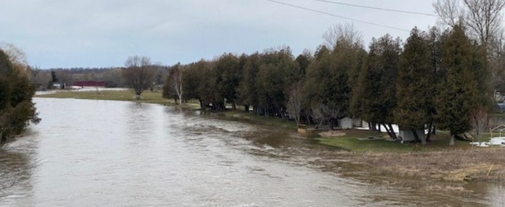
Water levels started climbing overnight Thursday. They’re expected to keep rising through the weekend. The Nith River at New Hamburg has already risen 1.2 metres above normal levels as of Friday morning. Another 50 centimetres is expected by Saturday evening.
- New Hamburg: Nith River corridor (population 3,200)
- Ayr: Downstream areas along Nith River (population 4,100)
- West Montrose: Speed River basin (population 1,100)
- Issued: March 7, 2026
- Duration: Through weekend
- Peak expected: Saturday 2 a.m.
Why the Rivers Are Going Crazy
A perfect storm of weather conditions is driving the surge. Even experienced flood watchers didn’t see this coming.
Rapid snowmelt combined with overnight rain has overwhelmed drainage systems across the region. Temperatures jumped from -5°C Wednesday evening to 12°C by Thursday afternoon. That’s a 17-degree swing in less than 24 hours. It accelerated snow pack melting way beyond normal spring rates.
The ground’s still frozen beneath the surface after a harsh winter that saw temperatures below -20°C for most of February. That means the water has nowhere to go except into rivers and streams. Hydrologists call this “impermeable surface conditions.”
Between Wednesday night and Friday morning, the region got 34 millimetres of rain on top of the melting snow. Weather stations recorded the heaviest rainfall between 2 a.m.
And 6 a.m. Thursday. Eighteen millimetres fell in just four hours.
“We’ve got about 30 centimetres of snow pack melting at an accelerated rate. Add the rain on top of that, and you get significant runoff that our systems simply can’t handle. The snow water equivalent in this pack is roughly 75 millimetres, which is like getting three inches of rain all at once.”
That assessment came from Sarah Chen, senior water resources engineer with the Grand River Conservation Authority. She spoke during a technical briefing Friday morning.
The Speed River at West Montrose has risen 98 centimetres above normal levels. Flow rates have increased from the typical 15 cubic metres per second to over 85 cubic metres per second. In Ayr, the Nith River’s moving at 92 cubic metres per second, compared to normal March flows of around 22 cubic metres per second.
Time to Get Moving
Local emergency management officials aren’t taking any chances. They’re coordinating the largest flood response in the region since 2018.
They’re telling residents in flood-prone areas to move valuables to higher ground immediately. Sandbags are available at municipal works departments. New Hamburg has distributed over 1,200 bags since Thursday evening. Ayr has handed out 850 bags.
West Montrose residents have picked up another 400.
Several roads are already underwater. That’s creating transportation headaches for commuters and emergency responders.
Highway 7 between New Hamburg and Shakespeare has standing water in multiple spots, with depths reaching 30 centimetres in some areas. Regional Road 17 south of Ayr is completely closed between Northumberland Street and Roseville Road.
Waterloo Regional Police have responded to 14 water-related vehicle incidents since Thursday morning. That includes two cars that became completely submerged when drivers attempted to handle flooded sections of Bleams Road near New Hamburg.
“If you see water on the road, turn around. Don’t try to drive through it. We’ve already had two vehicles get stuck this morning, and the water is only getting deeper. It takes just 60 centimetres of moving water to float a vehicle, and people consistently underestimate those depths.”
That was the message from Sergeant Mike Rodriguez of Waterloo Regional Police. He spoke at a news conference Friday afternoon, where officials outlined the growing scope of the emergency response.
Rural properties are getting hit hardest. Farmers are reporting widespread damage to equipment and livestock facilities. The Nith River has jumped its banks in at least 12 locations between New Hamburg and Ayr. That’s flooded roughly 200 hectares of agricultural land.
Been Here Before
This isn’t unprecedented for the region, but it’s been a while since conditions aligned to create such widespread flooding across multiple watersheds at the same time.
The last major flood event in New Hamburg was back in April 2018. The Nith River crested at 2.3 metres above normal levels. That flood caused about $2.3 million in damage to homes and businesses, affected 67 properties, and forced the temporary closure of the New Hamburg Community Centre.
The 2013 flood was worse in terms of displacement. It forced 89 people from their homes, closed three schools for three days, and caused an estimated $4.1 million in damages across the three communities. That event was triggered by similar rapid snowmelt conditions, though it occurred later in the spring when snow packs were typically lighter.
Climate data from Environment and Climate Change Canada shows these rapid melt events are becoming more common across southern Ontario. Between 1970 and 1999, the region experienced significant spring flooding an average of once every 4.2 years.
Since 2000, that frequency has increased to once every 2.8 years.
The issue stems from changing winter patterns. Average winter temperatures in the region have increased by 2.1°C since 1950. That creates conditions where snow accumulates through freeze-thaw cycles rather than staying consistently frozen. These unstable snow packs melt quickly when spring arrives. They often overwhelm drainage infrastructure.
Here’s the thing about infrastructure in these communities. It was built decades ago when flood patterns were more predictable. The storm sewer system in New Hamburg dates to the 1960s. It was designed to handle what engineers then considered a “100-year flood” event. Climate change has made those calculations obsolete.
Municipal engineers now estimate that what used to be considered 100-year flood levels occur roughly every 25 to 30 years under current climate conditions.
All Hands on Deck
Municipal crews have been working around the clock since Thursday morning. They’re deploying equipment worth over $180,000 to manage rising water levels.
They’ve got 12 high-capacity pumps running in low-lying areas. Each one can move 500 litres per minute. Storm drains are being cleared as fast as possible. Crews have removed debris from over 200 catch basins since the emergency began.
The Region of Waterloo activated its emergency operations centre Thursday at 6 p.m.
Worth watching.
That’s the first time it’s been fully operational since the COVID-19 pandemic began. Staff are monitoring water levels at 18 different gauge stations every hour. Real-time data feeds into flood prediction models.
Red Cross volunteers are on standby if evacuations become necessary. The organization has pre-positioned cots, blankets, and emergency supplies for up to 150 people at the New Hamburg Community Centre and the Ayr Fire Hall. So far, no evacuation orders have been issued. Officials say that could change rapidly though.
The Ontario Provincial Police have deployed their emergency response helicopter twice since Thursday. They’re assessing flood conditions from the air and identifying properties at immediate risk. Those flights revealed at least 15 homes with water approaching foundation levels.
Hydro One crews are monitoring electrical infrastructure closely.
Flooding knocked out power to 340 customers near Ayr Thursday evening. Power’s been restored, but crews are prepared to shut off electricity to flooded areas as a safety precaution.
“We’re in a watch-and-wait mode right now. The situation could change quickly if we get more rain than forecast, or if ice jams form upstream. We’ve got all our resources positioned and ready to respond, but Mother Nature is really calling the shots here.”
That assessment came from Janet Morrison, the region’s emergency coordinator. She’s managed flood responses for over 15 years.
What This Means Going Forward
Weather models show the immediate rain threat ending by Friday evening. Partly cloudy skies are expected through the weekend. But temperatures will stay above freezing. They’re hovering around 8°C Saturday and reaching 11°C Sunday. So the snow melt continues at an aggressive pace.
The Money Problem
Local businesses are already feeling the pinch as flooding disrupts normal operations and keeps customers away.
Several shops in downtown New Hamburg have moved inventory worth thousands of dollars off ground floors. The Nith River Brewing Company, a popular local brewery, had to close early Thursday. Water started seeping into their basement. That potentially affects $15,000 worth of stored ingredients and equipment.
Farm operations are taking a big hit across the region. Dairy farmers report they can’t get milk trucks in on flooded access roads.
Three farms were forced to dump roughly 12,000 litres of milk Thursday night because transport trucks couldn’t deal with the conditions.
Some livestock has been moved to higher ground as a precaution.
The Riverside Cattle Farm near Ayr relocated 85 head of cattle to a neighbour’s property after their lower pastures flooded (no, seriously). Moving costs and temporary housing for the animals will likely exceed $8,000.
The economic damage won’t be clear for days. Early estimates suggest it could exceed the $2.3 million in damages from 2018. Insurance adjusters are already getting calls from property owners dealing with flooded basements.
One major insurer reported 23 claims filed since Thursday morning.
Tourism operators are watching closely as the spring season approaches. The covered bridge in West Montrose, a popular photo spot that attracts over 50,000 visitors annually, is surrounded by water but still accessible. However, the nearby parking area is underwater. Visitors are forced to park nearly 200 metres away.
The New Hamburg Maple Syrup Festival is scheduled for March 20-21. It could be affected if flood damage persists. The event typically draws 15,000 visitors and generates about $180,000 in local economic activity.
What This Means for Your Wallet
The flooding in these three communities reflects a broader challenge facing municipalities across Ontario. Climate change is reshaping traditional weather patterns.
Similar conditions are developing in other parts of the province. Flood watches have been issued for communities along the Thames River near London and parts of the Trent River system north of Peterborough. The pattern suggests Ontario’s aging infrastructure isn’t keeping pace with changing precipitation and snowmelt patterns.
Provincial data shows flood-related insurance claims have increased 340% since 2000. Spring flooding now represents the highest single category of weather-related property damage in Ontario. The Insurance Bureau of Canada estimates that flood damage costs Ontario property owners over $125 million annually.
For residents in flood-prone areas across the province, this event serves as a reminder. Review emergency preparedness plans. Understand flood risks in your communities. Municipal emergency management offices recommend updating emergency kits, identifying evacuation routes, and understanding how local flood warning systems work.
The event also highlights the importance of watershed management and land use planning. Communities that have invested in natural flood management techniques typically experience less severe flooding. That includes wetland restoration and floodplain preservation. Areas where development has eliminated natural water retention features get hit harder.
Looking Ahead
River levels should start dropping by Monday if the weather forecast holds. Normal spring conditions are expected to return by mid-week.
The bigger question is long-term planning.
Will this latest flood event finally push forward infrastructure projects that have been stalled for years? Municipal officials are talking about flood mitigation projects that have been on the books since 2019.
A proposed $3.2 million retention pond near New Hamburg could help manage future flood events. It would store excess water during peak flow periods. The project has been stalled by funding disputes between municipal, provincial, and federal governments. Each level expects others to cover the majority of costs.
Similar infrastructure needs exist in Ayr and West Montrose (to put it lightly). Engineers have identified $8.7 million worth of upgrades needed across the three communities to handle flood events that are becoming increasingly common.
The province has committed $120 million over four years for municipal flood mitigation projects. But demand far exceeds available funding. Communities must compete for grants while dealing with immediate flood damage and emergency response costs.
“Every time we get flooding like this, we have the same conversation about infrastructure upgrades. The studies get done, the reports get written, and then we wait for the next disaster. Maybe this time we’ll actually do something about it before the next flood hits.”
That frustration came from Councillor Robert Hayes of North Dumfries Township, which includes Ayr. He spoke at an emergency council meeting Friday morning.
For now, residents are dealing with the immediate crisis. They’re hoping the worst-case scenarios don’t materialize.
Water levels are expected to peak Saturday night around 2 a.m. Emergency crews are maintaining 24-hour monitoring until conditions stabilize.
What This Means Going Forward
The next 48 hours will determine whether this becomes a manageable spring flood. Or whether it escalates into the kind of disaster that reshapes how these communities think about living with water.
Frequently Asked Questions
Which communities are under flood warning in Ontario?
New Hamburg, Ayr, and West Montrose are under flood warning as of March 7, 2026.
What’s causing the flooding in southwestern Ontario?
Rapid snowmelt combined with rain has overwhelmed drainage systems, with temperatures jumping from -5°C to 12°C in 24 hours.
When will flood levels peak in the affected areas?
Water levels are expected to peak Saturday night around 2 a.m., then start dropping by Monday.