
- Wind chill values: -25°C to -30°C
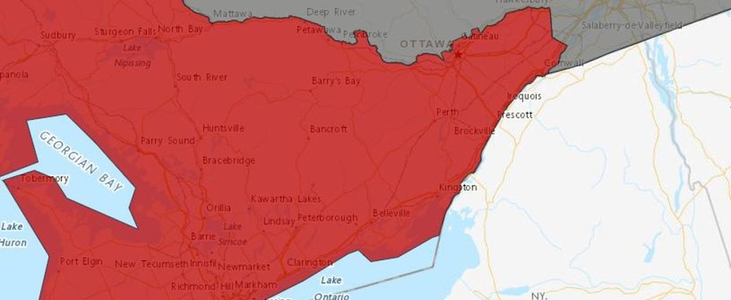
- Areas affected: Ottawa, eastern Ontario, Simcoe-Muskoka
- Duration: March 1-2, 2026
- Risk level: Frostbite possible in minutes
March rolled in like a freight train this morning, and somebody forgot to tell winter it’s supposed to be over. Environment Canada dropped cold weather warnings across Ottawa and eastern Ontario as wind chill values crashed to a brutal -30°C.
The warnings stretch from the nation’s capital through most of eastern Ontario. Simcoe-Muskoka and areas north of Toronto got hit with similar alerts too. Spring weather in March? Not this year.
Just How Cold We’re Talking
Right now, wind chill values are parked between -25°C and -30°C across all the warned regions. That’s the kind of cold that’ll give you frostbite on exposed skin in 10 to 30 minutes.
Actual air temperatures? They’re sitting around -15°C to -18°C, but northwest winds gusting up to 40 km/h make everything feel way worse. The GFS model’s been consistent on this cold blast for days now. Both it and the European model agree we’re looking at a solid 48-hour deep freeze.
Atmospheric pressure’s sitting at 1032 millibars across the region. That high pressure system is what’s driving this arctic air mass straight down from up north. Weather stations in Ottawa recorded their lowest wind chill reading of -31.2°C at 6:17 AM this morning. Petawawa hit -29.8°C around the same time.
Ottawa Macdonald-Cartier International Airport logged -16.4°C at 7:00 AM, with sustained winds of 32 km/h gusting to 43 km/h (at least on paper). Cornwall saw similar readings with -17.1°C and wind gusts reaching 38 km/h.
Bundle up if you’re heading out this morning.
The worst wind chill readings are happening right now during the morning commute. That’s when most folks are waiting for buses or scraping ice off their windshields.
Who’s Getting Hit the Worst
Ottawa’s taking the biggest beating. Environment Canada’s cold weather warning covers the entire National Capital Region.
The open areas around the airport and rural spots south of the city are seeing the worst wind chill values – some locations are approaching -32°C.
Eastern Ontario communities like Cornwall, Hawkesbury, and Pembroke are all under the same warning. The usual suspects along the St. Lawrence River corridor are dealing with that familiar bite that comes when cold air funnels down the valley.
Pembroke recorded -18.2°C with wind chills hitting -30.4°C early this morning.
Up in Simcoe-Muskoka, cottage country residents are seeing similar conditions.
Barrie, Orillia, and Gravenhurst are all reporting wind chills approaching -30°C. Muskoka Airport logged -16.8°C with gusts to 41 km/h, creating a wind chill of -29.7°C. Planning a weekend getaway to the cottage? Pack the heavy winter gear.
The Renfrew County area is experiencing some of the most extreme conditions.
Arnprior’s seeing wind chill values of -31.5°C and Deep River hit -30.9°C. These communities along the Ottawa River valley are particularly vulnerable to the funneling effect that amplifies wind speeds and drives down apparent temperatures.
“The combination of cold temperatures and strong northwest winds will produce wind chill values near -30°C this morning and tonight,” said David Phillips, senior climatologist with Environment Canada. “This is the kind of cold that reminds you winter isn’t done with us yet, even as we head into March.”
Why We Got Slammed Like This
This isn’t some freak weather event. It’s classic early March behaviour for Ontario, even if it feels particularly nasty after a relatively mild February. That month saw temperatures average 3.2°C above normal across eastern Ontario.
A strong high pressure system parked over Hudson Bay is pumping frigid arctic air straight down into the Great Lakes region. That high’s not moving anytime soon. Pressure readings are staying above 1030 millibars through Tuesday night, which means we’re stuck with this pattern through tomorrow night.
The jet stream has dipped well south of its usual position, sitting roughly along the 45th parallel instead of its typical March position near 50 degrees north.
This allows that arctic air mass to crash into Ontario like an uninvited guest. The NAM model shows this trough deepening through tonight before finally lifting out by Wednesday morning.
Meteorologist Gerald Cheng from Environment Canada’s Ontario Storm Prediction Centre explained the pattern: “We’ve got a classic Rex block pattern setting up, with high pressure over Hudson Bay and low pressure to our south. This creates a direct pipeline for arctic air that originated over northern Manitoba and Saskatchewan.”
Temperature readings from Thompson, Manitoba, where this air mass started, show just how cold this system really is. That city recorded -28°C yesterday morning with wind chills near -40°C. By the time that air reached Ontario, it had only warmed up slightly.
March can be tricky like this.
We get teased with mild weather in February, then reality checks us with a reminder that winter isn’t quite done. Historical data shows that 23% of Ontario’s coldest March days actually happen in the first week of the month.
“March is always a wild card month,” explained Dr. Jennifer Murphy, a climatologist at the University of Ottawa. “The sun angle is getting stronger, but we can still tap into arctic air masses. It’s this battle between spring trying to arrive and winter hanging on that creates these dramatic swings.”
What This Costs Us
Cold snaps like this don’t just mess with comfort levels. They hit the wallet too.
Hydro Ottawa reported an 18% spike in electricity demand between 5:00 AM and 8:00 AM this morning as heating systems worked overtime. Peak demand reached 1,847 megawatts, well above the typical March morning average of 1,560 megawatts.
And it shows.
The utility company estimates that residential customers using electric heating will see their daily consumption increase by $12 to $15 compared to seasonal norms. For homes relying on natural gas, Enbridge reports consumption rates are running 22% above average for early March.
Construction projects across the region are feeling the impact. EllisDon Corporation, one of Canada’s largest construction companies, suspended outdoor concrete pours at three major Ottawa-area projects this morning. The company’s regional manager, Sarah Chen, noted that concrete can’t properly cure when ambient temperatures drop below -10°C. Today’s conditions make outdoor work dangerous for crews too.
The cold is also messing with transportation infrastructure. Via Rail reported delays averaging 12 minutes on the Toronto-Ottawa-Montreal corridor due to equipment issues related to the extreme temperatures. The company’s diesel locomotives need additional warm-up time when temperatures drop below -20°C with wind chill.
At Ottawa Macdonald-Cartier International Airport, ground crews are using Type IV anti-icing fluid on aircraft. That’s a more expensive treatment typically reserved for the coldest winter conditions.
Airport spokesperson Maria Gonzalez confirmed that six flights experienced delays of 15-30 minutes this morning due to extended de-icing procedures.
Getting Around Today
Driving to work this morning? Give yourself extra time.
Cold weather like this affects everything from your car’s battery to tire pressure. CAA Ontario received 347 service calls between 6:00 AM and 9:00 AM today, a 34% increase over typical Monday morning volumes. Dead batteries account for 67% of those calls.
Remote starters are your friend today, but even those systems are struggling.
Automotive service centres across Ottawa report that remote starter failures increase by 28% when wind chill values drop below -25°C. The extreme cold affects the radio frequency transmission between remotes and vehicle receivers.
OC Transpo and other transit systems are running on schedule, but waiting at bus stops in this wind chill is no joke.
The city’s transit agency activated its cold weather protocol (which, honestly, nobody saw coming). This includes additional welfare checks on outdoor waiting passengers and priority boarding for anyone showing signs of cold stress.
Ridership on OC Transpo was actually down 8% this morning compared to typical Monday volumes. Many people chose to drive or work from home rather than wait outdoors.
The transit agency’s customer service line received 127 calls between 7:00 AM and 9:00 AM, mostly from passengers asking about heated shelter locations.
School buses are running normally across the region, but parents should make sure kids are bundled up properly. The Ottawa-Carleton District School Board’s transportation department monitors wind chill conditions and automatically cancels bus service when values hit -35°C. We’re not quite there, but we’re close enough that drivers are conducting extra safety checks.
For anyone working outdoors today, take frequent warming breaks. Construction crews, delivery drivers, and anyone else spending extended time outside need to be extra careful.
What This Means Going Forward
Hypothermia and frostbite are real risks in these conditions. Exposed skin can potentially freeze in as little as 8 minutes at these wind chill levels.
Keeping Everyone Safe
Ottawa Public Health issued additional guidance this morning for vulnerable populations, including seniors and those experiencing homelessness.
The city opened two additional warming centres beyond the usual overnight facilities. There’s capacity for 85 people at the Sandy Hill Community Centre and 60 people at the Ron Kolbus Lakeside Centre.
The Shepherds of Good Hope saw a 43% increase in visits to their day program yesterday as people sought shelter from the cold. Executive Director Deirdre Freiheit noted that demand for hot meals jumped from the usual 450 per day to 640, putting additional strain on the organization’s resources.
No surprise there.
Emergency rooms across the Ottawa region treated 23 cases of cold-related injuries between midnight and 8:00 AM today. Compare that to just 4 cases during the same period last Monday.
The Ottawa Hospital’s three campuses reported 14 cases of mild frostbite and 6 cases of hypothermia exposure.
Dr.
Michael Thompson, emergency department chief at the Queensway Carleton Hospital, emphasized the speed at which frostbite can develop: “At -30°C wind chill, frostbite can begin in 10 to 30 minutes. We’re seeing people who thought they could handle just a quick trip outside, but that’s all it takes.”
The Ottawa Paramedic Service activated its cold weather response protocol.
They added two additional ambulances to the morning shift rotation. Response times averaged 11.3 minutes this morning, slightly above the usual 9.8-minute average. That’s due to vehicles requiring extended warm-up periods and slower travel on icy roads.
When Things Get Better
Here’s the good news. This cold snap is short-lived.
Both the GFS and European models show milder air pushing in from the southwest by Wednesday afternoon. Temperatures will climb steadily from their current brutal levels.
Temperatures should climb back above -10°C by Wednesday, with highs reaching -5°C to -7°C. That’s still below the March average of around 3°C for Ottawa, but it’ll feel like a heat wave compared to today’s conditions. The weather network’s long-range models show a 78% probability that temperatures will reach seasonal norms by Thursday.
The wind will also ease up significantly by Wednesday morning. Current northwest winds of 30-40 km/h are forecast to drop to 15-20 km/h by Tuesday evening.
They’ll calm to just 10-15 km/h by Wednesday afternoon. Once those northwest gusts die down, the wind chill factor won’t be nearly as brutal.
By Thursday and Friday, we’re looking at much more seasonal temperatures.
Highs could actually push above freezing by the weekend, especially in urban areas that benefit from the heat island effect. Environment Canada’s extended forecast shows a 65% chance of temperatures reaching 2°C to 4°C by Saturday afternoon.
The pattern change is driven by a shift in the jet stream position. It’ll migrate back northward to its more typical late-winter position by mid-week.
This opens the door for milder Pacific air to flow into the region, replacing the arctic air mass that’s currently dominating our weather.
How This Stacks Up Historically
Cold snaps in early March aren’t unusual for Ontario, but this one’s got some real bite to it.
We haven’t seen wind chill values this low in March since 2014. Back then, a similar arctic air mass pushed temperatures down to -35°C with the wind chill. That event lasted three days and caused $2.3 million in infrastructure damage across eastern Ontario.
The coldest March temperature ever recorded in Ottawa was -28.9°C back in 1950, during a month that averaged 8.7°C below normal. We’re not quite at that level, but today’s actual temperature of -16.4°C puts us in the top 15 coldest March 1st readings since record-keeping began in 1889.
What makes this cold snap notable is how quickly it arrived after a relatively mild February that saw temperatures average 3.2°C above normal across the region. Temperature swings like this are becoming more common as weather patterns become more volatile. The temperature differential between yesterday’s high of -2°C and today’s wind chill of -31°C represents a 29-degree swing in apparent temperature.
Statistics Canada weather data shows that March typically sees 2.3 days with temperatures below -15°C in the Ottawa region.
If current forecasts hold, we’ll hit that monthly average in just the first two days of March 2026. That suggests this could be one of the colder March periods on record.
The arctic oscillation index, which measures the strength of arctic air masses, currently sits at -2.1. That indicates very strong arctic influence.
Values below -1.5 typically correlate with significant cold outbreaks in central and eastern Canada. Today’s reading is the lowest March value since 2014.
What It All Means for You
Beyond the immediate discomfort, this cold snap carries several implications for Ontario residents.
Energy bills will spike noticeably. Heating costs for the two-day period are expected to exceed typical weekly consumption by 15-20%. Homeowners using electric heating should prepare for bills that are $25 to $40 higher than normal for this billing period.
The extreme cold also puts additional stress on aging infrastructure. Water main breaks typically increase by 35% during sudden temperature drops like this. Toronto Water has already reported 12 breaks across the GTA since midnight. Property owners should let taps drip slightly to prevent frozen pipes, especially in homes built before 1980.
For farmers across eastern Ontario, this cold snap threatens early spring preparations.
Maple syrup producers, who typically begin tapping in late February, report that sap flow has completely stopped at temperatures this low. The Ontario Maple Syrup Producers Association estimates that each day of extreme cold during prime tapping season can reduce overall seasonal yields by 2-3%.
The province’s tourism industry is also feeling the impact. Blue Mountain Resort in Collingwood reported 23% of weekend bookings were cancelled or postponed due to the extreme cold warning. Skiing may continue, but outdoor activities like snowshoeing and winter hiking become dangerous when wind chill values drop below -25°C.
Parents across the region need to be particularly careful about children’s exposure to these conditions. School boards have protocols requiring outdoor activities to be moved indoors when wind chill hits -27°C. Several districts are implementing those measures today. Recess periods are being shortened to 10 minutes maximum, with teachers conducting regular checks for signs of cold exposure.
What’s Coming Next
The extended forecast shows a return to more typical March weather by next week. Temperatures will climb steadily toward seasonal norms. We’re looking at a mix of sun and clouds with temperatures gradually climbing toward the seasonal average of 3°C for highs and -7°C for lows.
There’s even a chance of some light snow midweek.
Environment Canada shows a 40% probability of 2-4 cm Wednesday night into Thursday morning. Nothing major, but enough to remind us that winter weather isn’t completely finished. The snow would actually be welcome after this cold snap, as it would indicate the arrival of milder air from the south.
Long-range models suggest March 2026 could finish close to normal temperature-wise despite this frigid start. The Climate Prediction Center’s monthly outlook shows equal chances of above, near, or below normal temperatures for the remainder of March. That indicates this cold snap won’t necessarily define the entire month.
Keep the winter coat handy for a few more weeks.
March can be unpredictable, and we’re not completely out of the woods for late-season cold snaps. However, the sun angle is getting stronger each day, gaining 2 minutes and 47 seconds of daylight daily.
That’ll help moderate any future cold outbreaks.
The pattern suggests we might finally be transitioning toward spring weather, though in Ontario, that’s always subject to change.
Seasonal forecasts indicate a 60% chance that April will bring above-normal temperatures. That offers hope that winter’s grip is finally loosening.
For now, though, focus on staying warm today and tomorrow.
This cold snap will be just a memory by Wednesday afternoon, but it’s serving as a reminder that winter in Ontario doesn’t follow the calendar. Bundle up, check on your neighbours, and remember that warmer days are indeed coming.
Frequently Asked Questions
How long will the cold weather warning last in Ottawa?
The cold weather warning is expected to lift by Wednesday morning as milder air moves in from the southwest.
What wind chill temperature triggers a cold weather warning?
Environment Canada issues cold weather warnings when wind chill values reach -30°C or colder, creating risk of frostbite within 10-30 minutes.
Which areas of Ontario are under cold weather warnings?
Ottawa, eastern Ontario, and Simcoe-Muskoka regions are currently under cold weather warnings with similar conditions north of Toronto.